
Advanced Mountain Navigation Course
Description:
Advanced Mountain Navigation Course - Snowdonia
Explore the stunning landscape of Snowdonia National Park in Wales with an advanced mountain navigation course. Get hands-on experience in navigating challenging terrain and take on challenges including ridge walks, map reading, and compass bearing with expert guidance from experienced instructors.
On this course you will learn.
- Recap basic skills
- Contour interpretation-map to ground and ground to map.
- Efficient timing and pacing stratejies
- Taking compass bearings and walking on bearings
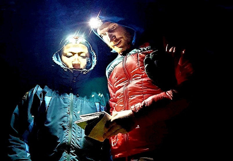
- Poor visibility navigation strategies. Attack points, aiming off, boxing
- Search techniques.
- Electronic aids
We will consider the following topics
This course covers essential skills to plan, navigate and assess terrain so that participants can enjoy off-track explorations with confidence
With the Advanced Mountain Navigation Course, you will gain comprehensive knowledge for navigating through any mountainous terrain confidently and safely. Learn essential techniques for locating your exact position in the landscape with a map, compass and GPS. Acquire the skills to plan off-track routes and make informed decisions about managing risk. Become comfortable with decision making skills in case of emergencies and adverse weather conditions.
Learn and refine skills for navigating in mountainous terrain
With this course, you will learn essential practical skills for navigating in the mountains. You will become familiar with all the main features of a map and how to use them effectively in conjunction with a compass. You will also refine your knowledge of how to plan, execute, and modify routes off-track or in unfamiliar terrain, as well as understand how to access accurate weather information. By the end of the course you will be confident in making informed decisions about risk management when faced with challenging conditions on the hill.
Assess terrain features, route options and potential hazard management plans
You will learn how to use a variety of features such as contour lines, grid references and symbols to identify potential routes between two points. You will also understand the best methods of evaluating a planned route and the importance of identifying any potential hazards along the route, such as rivers or cliffs. Lastly, you will learn how to assess the risk associated with different terrain in varying weather conditions, and develop your own hazard management plan for safe mountain navigation.
Utilise map, compass and GPS as key navigation tools
During this course you will develop your skills in using three key navigation tools - map, compass and GPS. You will learn both the theoretical knowledge behind these resources and practical techniques for using them effectively. You will develop an understanding of declination, grid references, contour lines and symbols on a map to locate yourself accurately on the terrain.
Understand safety considerations when going off-track
When going off-track in the mountains it is especially important to consider safety. Learning how to read a map accurately and be aware of your navigation is key in avoiding dangerous situations, such as being caught out by unexpected terrain or bad weather. During this course you will be shown simple rules and techniques to help you make safe decisions while travelling on unmarked routes in wild places. This includes understanding risk assessment, knowing when to stick to the paths, and how to check the weather forecast regularly.
Location:
Snowdonia, North Wales.
Duration:
1 day.
Price:
£45 per person (based on 3).
Experience Required:
Basic navigation skills.
Age Limit:
18+ (unless parent/guardian present then approx 14 yrs).
Equipment Provided:
Maps and Compass.
Dates:
Online Booking Form:
Downloads:
Booking Form (size: 186.3 kB)
Medical Form (size: 103.2 kB)
Gallery

![]()
![]()